FoxyWalk, terrestrial photogrammetry pole
Professional acquisition of terrestrial photogrammetry in pedestrian mode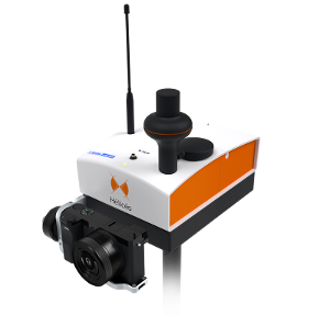
Description
FoxyWalk is a platform for easy terrestrial photogrammetry. It is aimed towards surveyors, topographers, architects, archaeologists. It allows the shooting of photos which would be inaccessible from the sky (facades, arches, etc.) and creation of 3D models. Perfect for complementary data acquisition of a drone survey. Terrestrial photogrammetry allows the survey of the shape and dimensions of inaccessible objects, study of deformations and analysis of structural anomalies. It may also be used in determining volumes. Terrestrial photogrammetry applications are varied : Reconstruction of facades, heritage conservation, monitoring structures and sites as well as supplementing aerial surveys and surveys of routes, ditches and open trenches with georeferencing networks (DT-DICT).
- Surveying equipment
- terrestrial photogrammetry
- gps surveys
- mobile mapping
Product characteristics
- Autonomy
- Up to 5 Hours
- Weight
- 3 Kg
- Sampling Distance
- Down to 1 cm (0.4 in) / pixel
Documents
Videos
Similar products
ZOLLER & FRÖHLICH GMBH
Germany

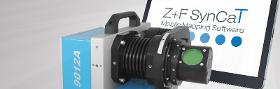
With the software Z+F SynCaT®, Zoller+Fröhlich creates a connection between the Z+F PROFILER® 9012 and external positioning and navigation systems. SynCaT stands for synchronization, calibration and transformation - also representing the main tasks of the software. Z+F SynCat® includes all the features below: Calibration: Processing of calibration parameters due to different system integrations (translation, rotation offsets between the coordinate systems of the navigation-unit (trajectory) and the Z+F PROFILER® 9012 laser scanner) Synchronization: Synchronize Z+F PROFILER® 9012 laser scanner data with trajectory data and generate 3D point cloud files Transformation: Transform 3D point cloud data to different local coordinate systems and apply different local/global height correction models (geoid correction files) Correction: Individual offset estimation referring to predefined ground control points (GCP’s) Z+F SynCaT® is a modular structured mobile mapping software.
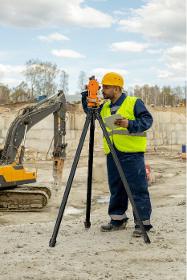
ROLATUBE TECHNOLOGY LTD
United Kingdom
THIS TRIPOD IS NOT TELESCOPIC - INSTEAD IT USES A UNIQUE ROLLABLE COMPOSITE. TRIED AND TESTED BY THE MILITARY FOR 20+ YEARS, NOW AVAILABLE TO NON-MILITARY CUSTOMERS. Using the unique Rolatube rollable composite for the legs, the ICT is able to roll up into the smallest pack size. With a choice of legs of 650mm or 1250mm in length, this small but mighty tripod can take top loads of up to 40kg. Optional accessories include peg plates and pegs or foot spikes, so your valuable equipment is secure and stable. The, when you're done, roll it all up and move on.
ZOLLER & FRÖHLICH GMBH
Germany
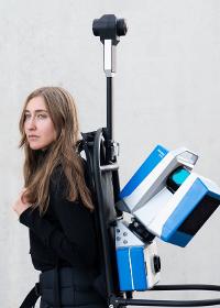
Highly accurate measurement results require static scans from multiple angles, whereas mobile solutions focus on efficiency. The Z+F FlexScan® platform developed by Zoller + Fröhlich combines the advantages of static scans with the efficiency of mobile systems. The perfect complement for any time-sensitive or large-scale application: AEC, facilitiy management, process industries, heritage documentation and forensics. + Universal mounting The Z+F FlexScan® 22 is highly versatile and can be easily used with various support systems. This SLAM platform can be attached to backpacks, tripod carts, fixed tripods, and robots. Thanks to the Quick Mount System, switching between support systems can be done in just a few minutes. Furthermore, data captured with different support systems can be effortlessly registered in Z+F LaserControl®.
ZOLLER & FRÖHLICH GMBH
Germany
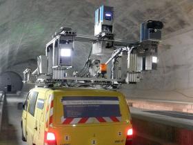
Zoller + Fröhlich has developed the Z+F PROFILER® 9012 and the Z+F PROFILER® 9020 laser scanners for mobile mapping applications, which can be flexibly integrated into the mobile mapping systems of almost all MMS providers. Railway applications on vehicle (train, etc.) and trolley platform Light space applications, for the inventory of tunnel tubes (railway and road), vegetation, signs and safety corridors Road applications (MMS) for road maintenance, traffic infrastructure detection, and general object acquisition Because of the high data capture rate, Z+F laser scanners operate accurately even from mobile platforms, at speeds of up to 120 km/h (approx. 75mph).
Request for quotes
Create one request and get multiple quotes form verified suppliers.
- Only relevant suppliers
- Data privacy compliant
- 100% free