4GNSS DEKART
GEODETIC GNSS RECEIVER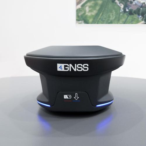
Description
DEKART is a universal GNSS geodetic accuracy receiver. It can be used as a Base or Rover in RTK mode. Raw data and coordinates are recorded in 32 GB* internal memory. The receiver is easily controlled by the Web Survey interface or any field software which is able to receive NMEA messages. Thanks to RTK&GO technology you can combine RTK points in Stop&Go Raw data to make your job anyway. Steady Stream technology will allow you to receive only the most stable correction stream from Base station automatically switching between all available channels: 2 SIM cards and UHF. The innovative 360 ° light indication gives a complete picture of the status of the receiver no matter which side you are watching. Batteries can be switched by the hot-swappable way. You can survey as long as need due to high battery capacity. 574 channels GPS: L1 C/A, L1/L2 P, L5 BeiDou: B1, B2, B3 GLONASS: L1, L2 Galileo: E1, E5a, E5b
- GPS
- survey
- GPS
- gps receiver
Documents
Similar products
EC PLAZA
South Korea

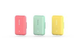
'Findme' - Clever and Accurate of Smart Location Tracker An intelligent location tracking device that sends and receives GPS locations using the LPWAN network. It can be used for various purposes, from vehicle or motorcycle location control to check the location of children and dementia patients. Also, it provides living safety services through emergency notification (SOS) functions. Product Specification Product Name: Findme Model Name: WAYBLE-FM100 Size: W 85mm x D 55mm x H 21mm Weight: 67g Input Power: Lithium Polymer 1300mAh 3.7v Frequency Band: LTE Cat.M1 B5 Charging terminal: Micro USB-C Type Usage time: About 2 days when fully charged (depending on charging and usage environment) Manufacturer and Country: DAEHO I&T Co., Ltd. / Republic of Korea Our Company Daeho I&T Co., Ltd. is a company specializing in ICT and nano SiC fiber heating technology that provides building central control solutions, IoT smart solutions, and nano SiC fiber heating solutions.
LALK GMBH &CO. KG
Germany
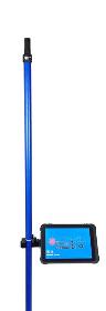
It features a quick start plug-in system that allows you to turn it on simply by plugging it together, which makes it an easy-to-use and complete system. Also the Rover rod features satellites such as GPS, GLONASS, Galileo, BeiDou, and more, ensuring that you get the most accurate readings possible. It also comes equipped with a powerful Helix antenna and Bluetooth connection to the rover rod up to 50 meters, eliminating the need for any annoying cables. The transport length of the rod is only 104cm, making it easy to carry around. It is robust and absolutely waterproof with a protection class of IP68, and it also features an integrated battery that can last for up to 10 hours with a percentage status display. This high-quality product is made in Schleswig-Holstein by Thomastechnik GmbH.

COLLETT & SONS LTD
United Kingdom
> Click on the "WEBSITE" link for more > Collett Consulting route access surveys take into account horizontal and vertical alignments, weight and dimensional issues across all types of roads, structures and environments. Used extensively for heavy transport, abnormal loads and wind turbine components, Collett Consulting's detailed route access surveys provide in-depth route analysis to identify the most suitable delivery path. Our route access surveys provide an outlined analysis of how your project, cargo or components will be delivered to their destination. With wind turbine blades increasing in size and the development of new equipment to facilitate heavy transport, it's imperative that delivery routes from port to pad site are surveyed in their entirety for any restrictions that could impact on delivery.
Request for quotes
Create one request and get multiple quotes form verified suppliers.
- Only relevant suppliers
- Data privacy compliant
- 100% free