AERO GEOMETRICS LTD.
Canada
Service Provider
AEROGEO provides some of the highest quality digital mapping services in the world. At AEROGEO we are technology leaders in flight planning and photo acquisition, LIDAR * acquisition and processing (Stereo lidargrams for vector data extraction). AEROGEO (Aero Geometrics Ltd.) serves clients globally: 3D Visualization, Acquisition of satellite imagery, Aerial Photo, Aerial triangulation, Digital Terrain Models, GIS, Ground survey and photo control, LIDAR, Orthophoto, Photogrammetric scanning, Physical 3D models, Remote Sensing, Scanning, Softcopy, Stereo satellite data capture, Survey, Terrestrial Laser Scanning Services and Volumetric Calculations GPS. * LIDAR is an acronym for Light Detection And Ranging and is defined as an optical remote sensing technology that can measure the distance to, or other properties of a target by illuminating the target with light, often using pulses from a laser.
Website
Service Provider
209-837 West Hastings Street, Vancouver , B. C. V6C 3N6
V6C3N6 Vancouver - Canada
Company info
Key figures
-
- Company headcount
- 11 – 50
Organisation
-
- pages.epage-home.site-status
- Registered office – Parent company
-
- Main activity
- Service Provider
Activities of AERO GEOMETRICS LTD.
- Laser apparatus and instruments
- scanning lasers
- lidar
- orthophoto
- mapping
europages also recommends
A selection of companies related to the activity:
A selection of products that might interest you
SUVIS GMBH
Germany

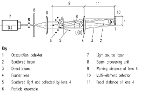
In various chemical or physical and technical processes particles of the order of 1 μm up to a few mm in size appear, whose size distribution is decisive or important for the process. There are many technical examples like in food production, pharmacy, process engineering, fuel burning in turbines, motors etc., slurry burning, and cosmetics. The laser diffraction particle sizer is capable to measure a particle size distribution from a collective of particles like a spray and to appropriately process, describe, and present it. The particle material may be solid or liquid in a gas or gas like air bubbles in a liquid. For the measurement it is only important, that the optical properties of the continuous and the dispersed phase are different. The laser diffraction particle sizer offers the advantage of a fast and non invasive measurement in a wide range of particle sizes. Especially in case of sprays or suspensions this method has become a standard measurement tool.

SUVIS GMBH
Germany
Particle size measurements are important in various applied sciences and in engineering, for example in fuel burning or in cavitation research as well as in particle size control. In all these applications it necessary to have knowledge about the particle dynamics. To gain that knowledge one has to measure the particle size and its velocity if possible in a noninvasive way with high local and temporal resolutions. A device which makes such measurements possible is the so called PhaseDopplerAnemometer (PDA), which has several advantages. First, it exhibits a large dynamic range from micrometer particles up to sizes in the millimetre range. Then it is very precise and no calibration procedure is necessary. Moreover, it is very robust against optical distortions. In the following the working principle of this flow and particle measurement technique will be explained.
SUVIS GMBH
Germany
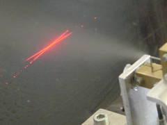
The measurement technique of LaserDopplerVelocimetry (LDV) is one of the most frequently applied modern measurement techniques in fluid mechanics to perform accurate local flow velocity measurements, which exhibits the advantage of a very high local and temporal resolution. Our technical department offers excellent conditions to perform such measurements (LDV).
EC PLAZA
South Korea
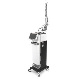
BIOXEL uses fine laser beam to minimize skin damage by heat and to shorten the recovery and rejuvenation period. Treatment time can be shortened by adjusting spot size and the beam density, which is beneficial for both of the operator and the patient. [Features] Fractional Mode & General CO2 Mode & Dental Mode & LVR Mode Reduced Pain & Excellent Effectiveness Three Patterns : ARRAY, GRID, RANDOM Smart & Various Protocols for User’s Convenience Max 4489 dots to an area of 20x20mm Various scan shapes: Square, Hexagon, Triangular, Circular [Application] Fractional Hand Piece Skin tightening, Wrinkles, Large Pore, Skin Resurfacing, Acne scar, Stretch Mark, Laser Peeling, Age Spot, Pudenda, etc. General Hand piece (50mm or 100mm) Mole, Wart, Freckles, Birthmarks, Tumor elimination, Condylom, Syringoma, Snoring.
Request for quotes
Create one request and get multiple quotes form verified suppliers.
- Only relevant suppliers
- Data privacy compliant
- 100% free