FoxyPro, VTOL airplane drone for photogrammetry
Vertical Take-Off and Landing airplane for large scale survey missions.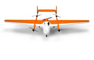
Description
FoxyPro is a fully automatic VTOL airplane created for long distance photogrammetry surveying. Available with a wingspan of 3 m or 3.5 m, FoxyPro is equipped with a vertical takeoff and landing system (VTOL), allowing it to take off and land on all types of sites. Thanks to its great in-flight stability, FoxyPro has a maximum load of 2 kg, allowing it to carry an HD sensor. With more than an hour of in-flight battery life, FoxyPro is capable of scanning up to 300 ha (741 acres) in a single mission. This drone is made for professionals of the measurement such as surveyors, topographers, archaeologists and responsible for quarries or mines.
- Surveying equipment
- photogrammetry
- vtol airplane drone
- RTK
Product characteristics
- Autonomy
- Up to 60 min
- Max takeoff weight
- 11 Kg
- Scan surface
- 100 ha (247 acres) to 300 ha (741 acres)
Videos
Request for quotes
Create one request and get multiple quotes form verified suppliers.
- Only relevant suppliers
- Data privacy compliant
- 100% free