PowerVision Oblique Image Viewer
Web-based Oblique Image Viewer Software
Description
PowerVision is a Web-based oblique imagery software developed by Birlik Harita. Basic Capabilities a) Measurement Vertical height of the objects, Horizontal distance, slope distance and height differences between two points, 3D coordinates of every detail visible on the aerial photograph, Areas on the oblique aerial photograph can be measured quickly and easily. b) Digitization Details can be vectorized as point, line, area and Point line and area objects digitized on the oblique aerial photograph can be exported in different formats. c) Vector Integration It is easy and fast to show existing 2D GIS layers on oblique images. The existing 2D GIS vector layer data sets can be converted 3D vector data sets via using digital terrain model (SAM), and the layer can be shown directly on oblique images.
Similar products
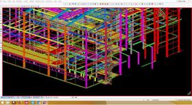
TRIBUNAS & FIGUEIREDO, LDA
Portugal

We work with the most modern 3D modeling tools to develop your projects quickly and efficiently. Software Tekla Structures and Solidworks.
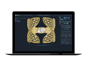
GRAVOTECH
France
Cutting edge 3D software for jewelry design that will keep your business ahead of the others. - DEDICATED JEWELRY TOOLS Using the modules like your workshop tools. Tucked away in a virtual drawer within the jeweler’s bench. - EASY TO LEARN, EASY TO MASTER 3Design thinks like a jeweler. You do not need to be an engineer to use this software. Design like the artist that you are! - HISTORY Optimize your creativity time. The parametric construction tree within 3Design is a big timesaving factor.
EWOQE GMBH & CO. KG
Germany
EWOQE provides model making, prototype construction, and 3D printing services for the industry. Our team of experts is highly skilled in designing and producing high-precision plastic components using advanced additive manufacturing technologies. We strive to offer swift and cost-effective solutions for your development projects, utilizing our efficient approach. Our state-of-the-art 3D printing techniques enable accelerated product development and shortened turnaround times. At EWOQE, we are committed to providing components that meet your specific requirements with the utmost quality and reliability. We understand the importance of these factors in the industry and are dedicated to meeting your expectations in every aspect. We would be honored to serve as your trusted partner for model making, prototype construction, and 3D printing services.
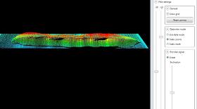
QUELLTECH GMBH
Germany
The QS View software package is intended for dimensional control in 2D or 3D QS-View 2D / 3D software for all measuring tasks 3D representation of an irregular body for determination of volume and weight. With the 2D / 3D software a wide variety of parameters can be processed and displayed, e.g. length, width, angle height, gap, presence, volume (resp. weight), seam geometry (height, width), gap dimensions. Due to the modular structure of the software, customized specialties can be added any time. Each module delivers the results to an individual output module. The universal SPC interface allows simple connection to S7 controllers via Ethernet. 2D / 3D software developer kits are available for integrators with corresponding knowhow.
Request for quotes
Create one request and get multiple quotes form verified suppliers.
- Only relevant suppliers
- Data privacy compliant
- 100% free