
HELICEO
France
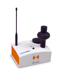
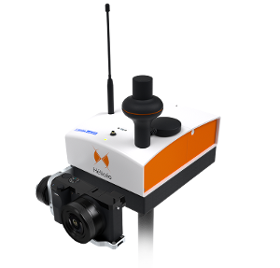
Hélicéo created the DroneBox technology in order to meet the demands of professionals for multiple applications as well as to address the economic challenge of needing multiple types tools. This “Plug & Play” device is adaptable across Hélicéo’s entire range of products, allowing you to perform precision measurement with multiple vehicles and sensors while reducing your investment. The DroneBox, which may be used onboard any Hélicéo vehicle, uses Network Real Time Kinematic (NRTK or RTK) technology, thus providing precision measurement using satellite corrections in real time in order to achieve precision measurement to centimeter accuracy. DroneBox has the following integrated key functions: GNSS geodetic mapping, autopilot, telemetry, archiving, communication, flight controller and avionics.
HELICEO
France
FoxyWalk is a platform for easy terrestrial photogrammetry. It is aimed towards surveyors, topographers, architects, archaeologists. It allows the shooting of photos which would be inaccessible from the sky (facades, arches, etc.) and creation of 3D models. Perfect for complementary data acquisition of a drone survey. Terrestrial photogrammetry allows the survey of the shape and dimensions of inaccessible objects, study of deformations and analysis of structural anomalies. It may also be used in determining volumes. Terrestrial photogrammetry applications are varied : Reconstruction of facades, heritage conservation, monitoring structures and sites as well as supplementing aerial surveys and surveys of routes, ditches and open trenches with georeferencing networks (DT-DICT).

CIRRUS RESEARCH FRANCE S.A.S
France
We’re proud to announce the launch of the new GPS-enabled Optimus+ sound level meter, designed to make environmental noise monitoring easier and more effective than ever before. The Optimus+ GPS builds on the incredible technology of Cirrus’ iconic Optimus range, by providing highly accurate location data for every measurement that’s taken. Optimus+ GPS automatically stores location data with each reading, which can be analysed in our licence-free data reporting software, NoiseTools. There’s no need to purchase a whole new noise measurement instrument to benefit from the GPS functionality, you can simply purchase the module and add it to your existing Optimus+ Red or Green device. It’s also available as a full sound level meter kit. With optimised battery life, the Optimus+ GPS is perfect for taking environmental noise measurements. The industry-leading time to first fix means that it is easier and faster than ever before to connect the module to a GPS signal.

Do you sell or make similar products?
Sign up to europages and have your products listed
Results for
Gps - Import exportNumber of results
3 ProductsCompany type