

SCHÜTZ GMBH MESSTECHNIK
Germany

With an electronically supported gas pipeline network survey, you have the following advantages: You take full advantage of the possibilities of your GIS. You reduce your effort considerably. You increase efficiency and security through digital documentation. You create better predictability and advantages for your work preparation You significantly increase the quality of the documentation
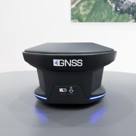
4GNSS (ORIENT SYSTEMS GROUP)
United Arab Emirates
DEKART is a universal GNSS geodetic accuracy receiver. It can be used as a Base or Rover in RTK mode. Raw data and coordinates are recorded in 32 GB* internal memory. The receiver is easily controlled by the Web Survey interface or any field software which is able to receive NMEA messages. Thanks to RTK&GO technology you can combine RTK points in Stop&Go Raw data to make your job anyway. Steady Stream technology will allow you to receive only the most stable correction stream from Base station automatically switching between all available channels: 2 SIM cards and UHF. The innovative 360 ° light indication gives a complete picture of the status of the receiver no matter which side you are watching. Batteries can be switched by the hot-swappable way. You can survey as long as need due to high battery capacity. 574 channels GPS: L1 C/A, L1/L2 P, L5 BeiDou: B1, B2, B3 GLONASS: L1, L2 Galileo: E1, E5a, E5b
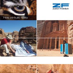
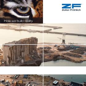
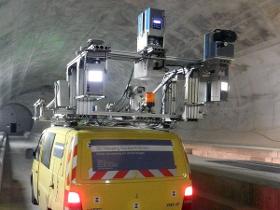
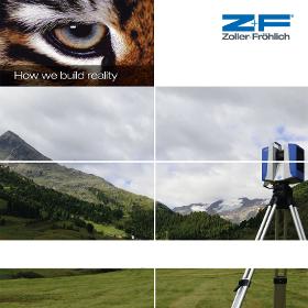
ZOLLER & FRÖHLICH GMBH
Germany
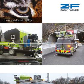
Zoller + Fröhlich has developed the Z+F PROFILER® 9012 and the Z+F PROFILER® 9020 laser scanners for mobile mapping applications, which can be flexibly integrated into the mobile mapping systems of almost all MMS providers. Railway applications on vehicle (train, etc.) and trolley platform Light space applications, for the inventory of tunnel tubes (railway and road), vegetation, signs and safety corridors Road applications (MMS) for road maintenance, traffic infrastructure detection, and general object acquisition Because of the high data capture rate, Z+F laser scanners operate accurately even from mobile platforms, at speeds of up to 120 km/h (approx. 75mph).
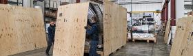
TRANSMEC BELGIUM
Belgium
With years of experience, we are able to manage all your packaging requirements, providing customised, cost effective and reliable packaging that has been tested and produced by our own companies. Our expert knowledge enables us to offer advanced solutions that are highly competitive and we can provide integrated packaging, logistics and transport services, removing the need for you to work with anyone else
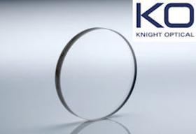
KNIGHT OPTICAL (UK) LTD
United Kingdom
Knight Optical offer a range of Stock Sapphire Windows, and custom for use within Airborne LiDAR Systems. These are systems used in surveying for topographical measurements. The data accumulated can be used to generate a Digital Terrain Model or a Digital Elevation Model which are 3D representations of terrain. Sapphire (Al2O3) is one of the hardest minerals and optical materials available for use in the range from UV up to 5µm. Making it ideal as a protective window for airborne systems which may be utilised in harsh environment or against birds! Sapphire is grown by various methods from seed samples. Sapphire can be polished to a high standard, but as it is the second hardest mineral on Earth it must be subject to high forces to polish. Therefore, windows made from Sapphire must have a thickness to diameter ratio of at least 10:1, that is, greater For more information read PDF….
EC PLAZA
South Korea
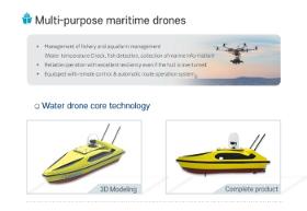
Description - Development of drones with unmanned remote range capable of coastal surveying, and the construction of control system capable of interworking and controlling survey information - Water Drone with Marine Remains and Sea Oil Film Treatment - Equipped with core technologies needed for maritime management, allowing for a variety of measurement and management tasks with only operation of developed drones to minimize waste of time and resources. Features · Real-time observation of weather, maritime and physical data using ultrasound radar, observation sensors. · Maritime drones for coastal observation and securing of water resources. · Life saving is possible in the event of a maritime accident. · Precise and stable surveying specialized drone · Remotely adjustable and self-driving · The small ship type capable of when necessary boarding · Mobile control system construction · Various addition function mount
FLUKE PROCESS INSTRUMENTS GMBH
Germany
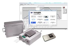
The Datapaq Furnace Tracker Temperature Uniformity Survey (TUS) System from Fluke Process Instruments features the choice of data logger (TP6 or XDL12), choice of thermal barrier (TB45 or TB46), thermocouples and our intuitive Temperature Uniformity Survey (TUS) Insight™ Software package to perform accurate in-process product thermal profiling while verifying conformity to all required specifications, including the AMS2750 standard. Data Loggers The Datapaq TP6 is the perfect solution for the most demanding high-temperature profiling applications with a 316-grade machined stainless-steel case and IP67 rating. Once combined with the Datapaq Insight™ or Datapaq Insight Furnace Surveying software you can display information from the data logger in real time via the optional Radio Frequency (RF) system or via standard USB/Bluetooth connections. Available in 10 and 20 channel configurations and two case styles Water resistant (IP67 rated) Communication via USB or Bluetooth
CYGNUS INSTRUMENTS LTD
United Kingdom
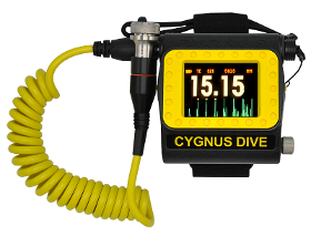
Cygnus DIVE is a wristmountable underwater ultrasonic thickness meter that has been designed for the professional diver and can be worn on the forearm, providing an invaluable free hand whilst performing an in water survey (IWS). It has a large bright display for easy viewing from all angles, by the diver and his camera/surface crew, even in poor visibility. Cygnus DIVE also hosts an array of other key features, such as Ascan to help verify measurements; data logging that enables hasslefree reporting and analysis; MSI™ to verify stable measurements; and AutoLog for automatically logging measurements without having to press any buttons. The Cygnus DIVE uses the multipleecho technique (approved by Class Societies) for accurate, reliable thickness measurements through coatings up to 20mm thick. This unit also incorporates singleecho and echoecho modes used for extreme corrosion and pitting, making it one of the most versatile underwater thickness gauges on the market.
CYGNUS INSTRUMENTS LTD
United Kingdom
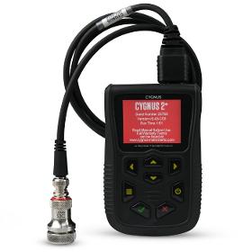
The Cygnus 2+ metal thickness gauge has an endmounted rotatable display designed for rope access work, providing a safer environment when working at height. As with all Cygnus thickness measurement instruments, the Cygnus 2+ uses the multipleecho mode for measuring through thick coatings (up to 20 mm thick in Deep Coat mode). As well as this, the Cygnus 2+ thickness gauge also incorporates the singleecho mode for measurements on uncoated surfaces with heavy front face and/or backwall corrosion, and the echoecho mode for measurements on painted metals with heavy back wall corrosion and pitting using a variety of portable UTM probes. Offering maximum strength and environmental protection, the Cygnus 2+ metal thickness tester is certified to stringent US MIL STD 810G standard and IP67.

Do you sell or make similar products?
Sign up to europages and have your products listed
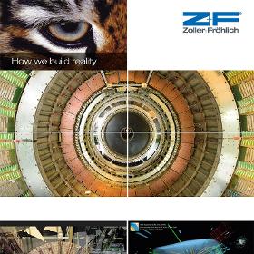
ZOLLER & FRÖHLICH GMBH
Germany
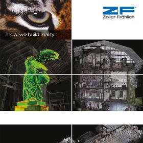
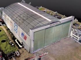
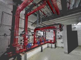
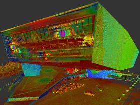
Existing factory workshops and industrial plants can be surveyed three-dimensionally in detail. For new buildings, further extensions and reconstruction in the future, there are spatial coordinates available which are accurate to a millimeter, from which two-dimensional construction plans can easily be drawn. Generation of 3D models From the data gathered by Z+F laser scanner systems and with the LFM software, 3D models of the actual state of the factory or plant (e.g. tubes, steel girders) can be generated. Furthermore, it is possible to generate complete CAD models from the 3D scan data (the so-called point cloud). Clash detection It is possible to simulate manufacturing processes and to carry out collision checks with 3D models. Example: Another production robot of the same type has to be added to an existing plant. Facility management All fixed equipment like cables or tubes is surveyed as well and saved in a 3D database which serves as the basis for future reconstruction.
ROLATUBE TECHNOLOGY LTD
United Kingdom
THIS TRIPOD IS NOT TELESCOPIC - INSTEAD IT USES A UNIQUE ROLLABLE COMPOSITE. TRIED AND TESTED BY THE MILITARY FOR 20+ YEARS, NOW AVAILABLE TO NON-MILITARY CUSTOMERS. Using the unique Rolatube rollable composite for the legs, the ICT is able to roll up into the smallest pack size. With a choice of legs of 650mm or 1250mm in length, this small but mighty tripod can take top loads of up to 40kg. Optional accessories include peg plates and pegs or foot spikes, so your valuable equipment is secure and stable. The, when you're done, roll it all up and move on.
ZOLLER & FRÖHLICH GMBH
Germany
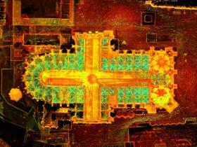
For listed buildings, there are regular new construction tasks. Often there are no adequate plans on the basis of which planning, modernization or renovation can be carried out. Due to the very high scan rate of more than 1 million measured values per second, range resolution in the millimeter range and a measuring accuracy in the mm range, even the capture of the finest structures and details is still possible with the 3D laser scanners from Zoller + Fröhlich. The 3D documentation is therefore the ideal prerequisite for reconstructions of, for example, design conditions or sensitive stucco work. The recorded inventories, damage, structures and details are recorded in databases and allow a faithful reconstruction of the entire object or of parts of the object at any later time.
ZOLLER & FRÖHLICH GMBH
Germany
Z+F 3D phase based laser scanners enable a detailed condition and damage assessment. Due to the high sampling rate as well as a range resolution of less than 1mm and a measurement accuracy of millimetres, even the most delicate structures and details can be documented. The surveyed status, damage, structures and details are stored in a database which allows the reconstruction of the complete object or parts of the object at any given time in the future.
ZOLLER & FRÖHLICH GMBH
Germany
In many projects insurance companies have the problem that the building to be insured is either not completely documented or was documented a long time ago, so that the available data is out of date. 3D laser scanning is an efficient way to detect the current condition of the building and all its details. The 3D data is particularly useful for insurance companies when it comes to the following tasks: Assessment of property value Surveying the inventory in 3D Calculation of areas In fact the 3D data is of particular importance in the case of damage. A new survey of the damaged object can be carried out and by using software, the condition before and after the damage can be compared and visualised directly. The amount of damage can be quantified much more precisely in comparison to a quantification without the use of 3D data.
ZOLLER & FRÖHLICH GMBH
Germany
In the management of large buildings, it is important to have current plans of facades, facilities, furnishings, piping and paths to carry out renovation and conversion work. An exact calculation of the costs is only possible with detailed and current plans. Thanks to the high level of flexibility and user-friendly handling of the Z+F IMAGER®, the laser scanner can easily be integrated into the fields of facility management without a long training period.
ZOLLER & FRÖHLICH GMBH
Germany
Z+F 3D phase based laser scanners enable a detailed condition and damage assessment of the current status of a building or complex structure and its surroundings. It is easy to create 2D floor plans or views of the object to plan building or conversion projects of the 3D data. Therefore, 3D data is an ideal planning basis for structural measures. For site measuring, 3D documentation is just the right technology, because you will save time and money. Moreover you can evaluate different options of how the available rooms can be used without accessing the site in reality. The whole work can be done from your office desk and the data will be available even after many years. Structural damages Structural damages always mean economic loss for the owner and user of a building, and can influence the future value of a property significantly.
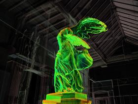
ZOLLER & FRÖHLICH GMBH
Germany
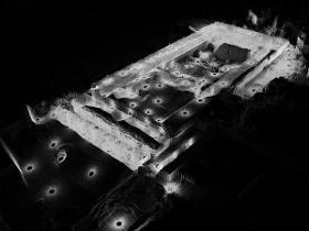
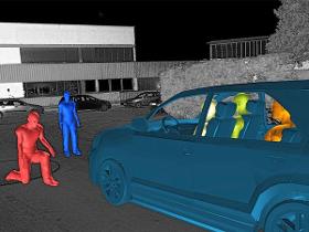
Within a few minutes, Z+F 3D laser scanners can provide accurate measurement data of crime scenes and accidents – indoors and outdoors. This data speeds up the investigation process by "freezing" the scanned crime scene and documenting it. These evaluations are accepted in court. Accident investigation The phase based 3D laser scanners of Z+F enable an accurate three-dimensional capturing of complete accident scenes with all the details like deformations of the vehicles or skidmarks. Using this technology, the question of the possible causes and sequence of the accidents can be analysed and answered more easily. Crime scene investigation The complete securing of evidence at crime scenes and the geometry measurement on the spot are of great importance. A crime scene is normally captured from various positions by the Z+F IMAGER®. By combining these scans, the viewer gets an overview of the complete scene.

VISTIM SA
Luxembourg
Explore our Recruitment Process Outsourcing (RPO) services on our website. At VISTIM, we understand the importance of finding the right talent to drive your business forward. Our RPO services are designed to help you streamline your recruitment processes and find the best candidates for your organization. Whether you need assistance with sourcing, screening, or onboarding, our team of recruitment experts is here to support you every step of the way. By outsourcing your recruitment processes to us, you can benefit from cost savings, increased efficiency, and access to our extensive network of candidates. We offer tailored solutions to meet the unique needs of your business, ensuring that you find the talent you need to succeed. Discover how our RPO services can help you build a high-performing team by visiting our website today.
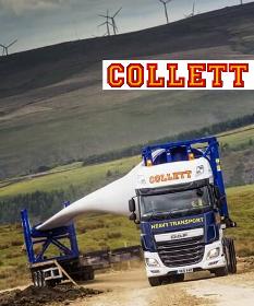
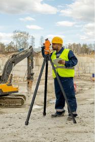
COLLETT & SONS LTD
United Kingdom
> Click on the "WEBSITE" link for more > Collett Consulting route access surveys take into account horizontal and vertical alignments, weight and dimensional issues across all types of roads, structures and environments. Used extensively for heavy transport, abnormal loads and wind turbine components, Collett Consulting's detailed route access surveys provide in-depth route analysis to identify the most suitable delivery path. Our route access surveys provide an outlined analysis of how your project, cargo or components will be delivered to their destination. With wind turbine blades increasing in size and the development of new equipment to facilitate heavy transport, it's imperative that delivery routes from port to pad site are surveyed in their entirety for any restrictions that could impact on delivery.
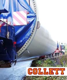
COLLETT & SONS LTD
United Kingdom
> Click on the "WEBSITE" link for more > Our Transport Consulting experts possess the knowledge, experience and skills to analyse the surrounding topography and the impact of abnormal loads & heavy transport projects on the surrounding environment. Collett Transport Consulting topographical surveys are used to map the contours of the ground and existing features to assist with route planning and necessary modifications for abnormal load & heavy transport projects. This process, undertaken in the early days of our planning allows us to identifying any features which which could potentially impact on any abnormal load or heavy transport projects. The data gathered by Collett Transport Consulting from site visits and swept path analysis, coupled with data gathered during topographical surveys, provides the most accurate indication of any third party land requirements, road widening or pinch points along the route.
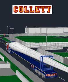
COLLETT & SONS LTD
United Kingdom
> Click on the "WEBSITE" link for more > Our SPA software identifies height limitations, predictably evaluates vehicle movements and provides an accurate representation of a vehicle and load’s movement throughout any chosen transport route. Collett’s expert Transport Consulting Team provide detailed 2D & 3D swept path analysis reports and transport analysis, allowing us to accurately analyse the impact of abnormal loads and heavy transport projects. Our knowledge and expertise allows us to create 2D & 3D digital models of loaded delivery vehicles using our transport analysis and design software to provide intricate route planning reports and meticulous analysis of the vehicle's behaviour in the surrounding environment. Each vehicle model designed by the Collett Team is specifically created for each individual abnormal load or heavy transport project, based on exact vehicle dimensions and features accurate vehicle movement characteristics
Results for
Survey - Import exportNumber of results
57 ProductsCountries
Company type
Category
- 3D scanner (18)
- Surveying equipment (10)
- Marine surveyors (5)
- Transport - heavy loads (4)
- Measurement - Equipment & Instruments (3)
- GPS (2)
- Windmills (2)
- Custom packaging - companies (1)
- Digging and boring - works (1)
- Industrial robots (1)
- Infrared tubes (1)
- International freight (1)
- Lenses, camera (1)
- Marketing - research (1)
- Mobile Phones (1)
- Multimedia - Internet and Intranet services (1)
- Optical measuring equipment (1)
- Personnel recruitment (1)
- Property developers, commercial and industrial (1)
- Quality control and certification (1)