
HELICEO
France
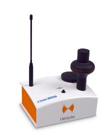
Hélicéo created the DroneBox technology in order to meet the demands of professionals for multiple applications as well as to address the economic challenge of needing multiple types tools. This “Plug & Play” device is adaptable across Hélicéo’s entire range of products, allowing you to perform precision measurement with multiple vehicles and sensors while reducing your investment. The DroneBox, which may be used onboard any Hélicéo vehicle, uses Network Real Time Kinematic (NRTK or RTK) technology, thus providing precision measurement using satellite corrections in real time in order to achieve precision measurement to centimeter accuracy. DroneBox has the following integrated key functions: GNSS geodetic mapping, autopilot, telemetry, archiving, communication, flight controller and avionics.
EC PLAZA
South Korea

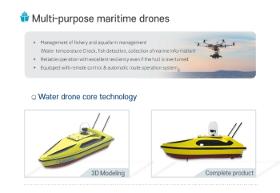
Description - Development of drones with unmanned remote range capable of coastal surveying, and the construction of control system capable of interworking and controlling survey information - Water Drone with Marine Remains and Sea Oil Film Treatment - Equipped with core technologies needed for maritime management, allowing for a variety of measurement and management tasks with only operation of developed drones to minimize waste of time and resources. Features · Real-time observation of weather, maritime and physical data using ultrasound radar, observation sensors. · Maritime drones for coastal observation and securing of water resources. · Life saving is possible in the event of a maritime accident. · Precise and stable surveying specialized drone · Remotely adjustable and self-driving · The small ship type capable of when necessary boarding · Mobile control system construction · Various addition function mount
HELICEO
France
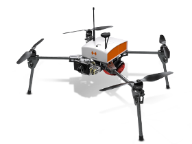
Its light structure and engine allow for extreme maneuverability with manual piloting. Designed for automatic photogrammetry missions up to 1.5 km², Fox4 may also carry out missions for inspection of infrastructure, structures, network lines or industrial sites, in automatic or manual mode. Perfect for your daily mapping missions and calculations of cubature, this quadcopter allows for photo collages, georeferenced orthophotos and point clouds as well as DTM / DSM. This drone is made for professionals of the measurement such as surveyors, topographers, archaeologists and responsible for quarries or mines.
HELICEO
France
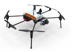
Its solid structure and in-flight stability allows its use on a wide variety of sites. Fully automatic, the Fox6 can carry out photogrammetry missions of up to 1.5 km². It is the perfect tool for large scale mapping missions as well as for static work and volume measurements. Thanks to its HD sensor and compatibility with DroneBox RTK, the Fox6 provides high precision for georeferenced photo collages, orthophotos, point clouds and DTMs / DSMs. This drone is made for professionals of the measurement such as surveyors, topographers, archaeologists and responsible for quarries or mines.
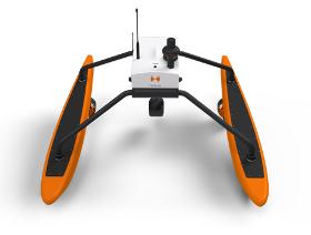
HELICEO
France
FoxBathy is an automatic bathymetric drone catamaran with double electric propulsion, which allows productivity, safety and precision in aquatic surveying. It ensures the safety of the operator, who may remain on the bank thanks to fully automated steering. FoxBathy not only helps in monitoring ports, marinas, sea areas, rivers, creeks, lakes and ponds or lagoons but also helps to identify critical areas or dangerous objects for navigation. Finally, it allows periodic monitoring of siltation and supervision of marine sites by performing calculations of cubatures and editing DTMs (Digital Terrain Models).
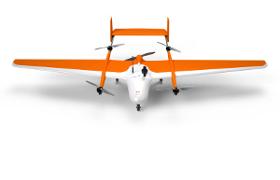
HELICEO
France
FoxyPro is a fully automatic VTOL airplane created for long distance photogrammetry surveying. Available with a wingspan of 3 m or 3.5 m, FoxyPro is equipped with a vertical takeoff and landing system (VTOL), allowing it to take off and land on all types of sites. Thanks to its great in-flight stability, FoxyPro has a maximum load of 2 kg, allowing it to carry an HD sensor. With more than an hour of in-flight battery life, FoxyPro is capable of scanning up to 300 ha (741 acres) in a single mission. This drone is made for professionals of the measurement such as surveyors, topographers, archaeologists and responsible for quarries or mines.

Do you sell or make similar products?
Sign up to europages and have your products listed
Results for
Topographical survey by drone - Import exportNumber of results
6 ProductsCountries
Company type